
The CoLLaboratoire for Activating Multi-modal Mobility (CAMMM) research project has developed the CAMMM Atlas, a digital platform designed to analyze and address socio-economic disparities related to accessibility in urban environments. This initiative aims to promote more equitable urban development by highlighting underserved areas and advocating for better distribution of services.
Origins and Development of CAMMM Atlas
Collaborative Efforts and Initial Focus
The CAMMM Atlas project originated from the collaborative efforts of Carmela Cucuzzella, a professor and dean of the Faculty of Urban Planning at Université de Montréal, Anne Cormier, a professor of architecture at UdeM, and Pierre Gauthier, an urban-planning professor at Concordia University. Initially, the project’s primary focus was on accessibility to public transit across different cities and neighborhoods, aiming to identify disparities and improve overall transportation networks. Over time, the scope expanded to encompass broader accessibility issues within urban centers, including access to essential services like healthcare and educational institutions, and availability of green spaces.
Their collaborative foundation is essential in ensuring the platform addresses multifaceted urban planning challenges comprehensively. This interdisciplinary approach combines expertise from urban planning, architecture, and social sciences to better understand and address the wide-ranging factors contributing to urban inequalities. By leveraging insights from multiple fields, the CAMMM Atlas platform can provide a more holistic analysis of urban accessibility and advise on more effective, inclusive development policies.
Current Development and Support
The current development of the platform is spearheaded by PhD students Firdous Nizar from UdeM and Omar Ortiz Meraz from Concordia University, who bring fresh perspectives and innovative solutions to the project. This advanced development phase is further supported by the Autorité régionale de transport métropolitain (ARTM), ensuring that the platform remains relevant and comprehensive in addressing urban accessibility challenges. Their collective goal is to integrate newer data sets and analytical tools into the CAMMM Atlas, making the platform more user-friendly and robust in its capabilities.
By incorporating real-time data and advanced analytics, Nizar and Meraz aim to maintain the platform’s cutting-edge relevance in addressing the ever-evolving landscape of urban mobility and accessibility. The support from ARTM, a significant regional transportation authority, underscores the practical importance and applicability of the CAMMM Atlas. Their endorsement and resources provide vital backing that can accelerate the platform’s development, reach more stakeholders, and implement crucial transportation and accessibility improvements efficiently.
Features and Analytical Capabilities of CAMMM Atlas
Levels of Analysis
The CAMMM Atlas platform organizes information into three levels of analysis: Neighborhoods, Transportation Hubs, and Access Points. Each level provides a unique perspective on urban accessibility and highlights different aspects of spatial equity. Neighborhoods are examined based on features such as access to transport, availability of green spaces, and proximity to essential services like grocery stores and healthcare facilities. This allows for a detailed understanding of how well different areas are served and which neighborhoods require more attention and resources.
Transportation hubs, which include strategic locations that link different modes of transport, are analyzed for their role in urban connectivity. By assessing these hubs, the platform can determine their overall effectiveness in connecting people to larger transit networks and identify any gaps in service that might hinder accessibility. Access points, such as metro stations and bus stops, are then assessed for their contribution to spatial equity. By evaluating these crucial points, the platform helps identify areas where transportation infrastructure can be improved to ensure more equitable access for all residents.
Comparative Analysis
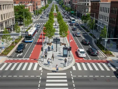
Through its comparative analysis, the CAMMM Atlas evaluates geographic areas for multimodal accessibility, public transit services, bike path networks, and pedestrian infrastructure. This comprehensive approach enables the platform to provide a holistic view of urban mobility and identify key areas that require improvement. For example, the borough of Dollard-des-Ormeaux, which lacks metro or suburban train services, is rated 2 out of 10 for multimodality, indicating a significant need for service expansion. Such comparisons help policymakers and urban planners prioritize investments and initiatives that will have the most impact on improving accessibility.
The platform also compares other crucial aspects such as the distribution and condition of bike lanes and pedestrian paths. These comparisons shed light on how well different areas support alternative modes of transportation, such as cycling and walking. Assessing the infrastructure’s current state allows stakeholders to identify and address specific areas where enhancements are necessary. This data-driven comparative analysis ensures that urban development efforts are focused on creating more balanced and accessible transportation networks, ultimately promoting greater spatial equity across urban centers.
Addressing Green Spaces and Universal Accessibility
Availability and Accessibility of Green Spaces
Another important aspect of the platform’s analysis is its consideration of green spaces, both in terms of availability and accessibility, as well as the green canopy of an area. Green spaces are crucial for the well-being of urban residents as they provide recreational areas, improve air quality, and offer psychological benefits. By analyzing the distribution of green spaces, the CAMMM Atlas helps identify areas that lack sufficient green spaces and may require additional parks or recreational facilities. This analysis is vital for creating healthier, more livable urban environments.
The platform’s focus on the green canopy of an area further emphasizes the importance of green spaces. A well-developed green canopy can significantly impact the local climate, reduce the urban heat island effect, and enhance the overall aesthetic of neighborhoods. By identifying areas with insufficient green coverage, the CAMMM Atlas enables urban planners to implement tree-planting initiatives and other environmental improvements that contribute to a more sustainable and pleasant urban environment. This holistic approach to green space analysis ensures that all residents have access to the benefits provided by well-maintained natural areas.
Universal Accessibility
The platform also examines universal accessibility by rating local infrastructures on their ability to meet the needs of people with reduced mobility. This promotes inclusive environments and ensures that urban development caters to all residents, regardless of their physical abilities. By evaluating the accessibility of various infrastructures, such as public buildings, transportation systems, and recreational facilities, the CAMMM Atlas helps identify barriers that prevent individuals with disabilities from fully participating in urban life.
Promoting universal accessibility is essential for creating truly inclusive urban environments. By highlighting areas that need improvement, the CAMMM Atlas assists policymakers and planners in making informed decisions about where to allocate resources and implement accessibility enhancements. These improvements not only benefit people with disabilities but also create more user-friendly spaces for all residents, including the elderly, families with young children, and individuals with temporary mobility limitations. Ensuring that urban infrastructure is designed with accessibility in mind contributes to a more equitable and inclusive society.
Potential Applications and Future Enhancements
Influencing Urban Planning Practices
The platform’s potential applications are far-reaching. According to Carmela Cucuzzella, certain neighborhoods such as Plateau Mont-Royal or Mile End are frontrunners in accessibility due to their easy access to essential services and diverse transportation options. Conversely, areas like Westmount face unique challenges due to their geographical features, which hinder walkability and limit access to public transportation like the metro. By providing clear, detailed analysis, the CAMMM Atlas can guide urban planners in addressing these unique challenges and enhancing accessibility in diverse neighborhoods.
By offering data-driven insights, the CAMMM Atlas can influence urban planning practices and promote more equitable development. Planners can use the platform to identify areas that require targeted interventions and prioritize investments in infrastructure and services that will have the most significant impact on accessibility. This evidence-based approach ensures that resources are allocated efficiently and effectively, ultimately leading to more inclusive and accessible urban environments. The platform’s comprehensive analysis also fosters collaboration between various stakeholders, including government agencies, real estate developers, and community organizations.
Development of a Spatial Equity Index
By providing a detailed picture of urban disparities and facilitating data-driven comparisons, the CAMMM Atlas lays the groundwork for developing an overall spatial equity index. This insightful composite indicator would capture service accessibility and quality within various city sectors or neighborhoods. While this index is still in the conceptual phase, it offers the prospect of informing government decision-makers and real estate developers about systemic inequities, thereby encouraging the creation of more inclusive and equitable urban infrastructures. Such an index would serve as a powerful tool for monitoring and evaluating the effectiveness of urban development initiatives.
The spatial equity index could become a standard metric for assessing the success of urban planning projects and policies. It would allow for ongoing evaluation and refinement of strategies to ensure that all residents benefit from accessible and well-distributed services. Additionally, the index could help identify best practices and successful interventions that can be replicated in other areas, promoting a more consistent approach to equitable urban development. By continuously updating and refining the index based on new data and insights, the CAMMM Atlas can remain a valuable resource for guiding urban planning efforts and promoting spatial equity.
Leveraging Open-Data Sources
Data Sources and Analysis
The CAMMM project leverages open-data sources for its analyses, such as General Transit Feed Specification (GTFS) files, OpenStreetMap databases, and municipal and provincial data on infrastructure and urban density. These data sources provide a comprehensive view of urban environments and help identify areas that require improvement. Using open-data ensures that the platform relies on accurate, up-to-date information and allows for more transparent analysis. Open-data also enables other researchers and stakeholders to access the same information, fostering collaboration and shared understanding.
By integrating various data sources, the CAMMM Atlas can offer a more nuanced view of urban accessibility. The combination of GTFS files and OpenStreetMap data allows for detailed analysis of transit networks, traffic patterns, and pedestrian pathways. Municipal and provincial data on infrastructure and urban density provide additional context, helping to identify areas where population density or existing infrastructure may impact accessibility. This multi-layered approach ensures that the platform’s analyses are robust and reflective of the real-world complexities of urban environments.
Future Indicators
In the future, the project team plans to incorporate additional indicators like average housing costs. This would offer deeper insights into how economic and social dynamics affect spatial equity, further enhancing the platform’s analytical capabilities. By including factors such as housing affordability, the CAMMM Atlas can provide a more comprehensive view of urban accessibility, addressing not only physical access to services but also the economic barriers that may prevent individuals from living in well-serviced areas.
Incorporating additional indicators will allow the platform to address a broader range of issues related to spatial equity. For example, analyzing housing costs alongside accessibility data can help identify areas where rising rents or property prices may be displacing residents and creating new accessibility challenges. This information can guide policymakers in developing strategies to promote affordable housing and prevent displacement. By continually expanding the range of indicators, the CAMMM Atlas can remain a dynamic tool for addressing the evolving challenges of urban development and promoting equitable access to services.
Promoting Equitable Urban Development
Addressing Socio-Economic Disparities
In summary, the CAMMM project’s Atlas platform represents a significant innovation in urban planning by focusing on the equitable distribution of services. It addresses socio-economic disparities that are often rooted in and amplified by inequities in access to transportation, green spaces, local services, and general community safety. By providing intuitive, detailed visualizations of urban data, CAMMM Atlas aims to influence urban-planning practices and policies. The platform’s analyses can guide efforts to prioritize investments and interventions that promote more balanced and inclusive urban environments.
By addressing these socio-economic disparities, the CAMMM Atlas can help create urban environments that support the well-being and prosperity of all residents. Improving access to transportation, green spaces, and essential services can enhance quality of life, promote social cohesion, and reduce health disparities. The platform’s focus on equitable service distribution ensures that resources are allocated where they are needed most, benefiting underserved communities and promoting overall social equity. This holistic approach to urban planning can foster more resilient and inclusive cities.
Influencing Policies and Collaboration
The CoLLaboratoire for Activating Multi-modal Mobility (CAMMM) has embarked on an innovative research project resulting in the creation of the CAMMM Atlas. This groundbreaking digital platform is specifically designed to analyze and address socio-economic disparities concerning accessibility in urban settings. By identifying underserved areas and advocating for a more equitable distribution of services, the CAMMM Atlas hopes to foster fairer and more inclusive urban development.
The CAMMM research team meticulously collects and examines data related to transportation, housing, and public amenities, among other factors, to provide a comprehensive understanding of how different urban communities are served. By doing so, they are able to pinpoint gaps and inefficiencies that adversely affect certain populations.
The ultimate goal of the CAMMM Atlas is to ensure that all residents, regardless of their socio-economic status, have equal access to essential services and opportunities. This initiative not only highlights areas in need of improvement but also proposes actionable solutions to bridge these gaps, thus promoting a more balanced and just urban environment.