
The rapid deployment of uncrewed aerial systems as primary responders marks a significant shift in how municipal emergency services manage critical incidents and allocate resources across urban environments. By launching drones immediately upon a 911 call, cities are drastically reducing response times, often arriving at a scene minutes before traditional ground units can navigate through dense traffic or complex terrain. This technological leap provides dispatchers with an immediate visual feed, allowing for better-informed decisions regarding the necessary number of police officers, firefighters, or paramedics. However, this increased visibility brings forth complex questions regarding the surveillance of private citizens and the management of sensitive data. Balancing the undeniable benefits of saved lives and increased officer safety with the fundamental right to privacy requires a robust policy framework. Municipalities are now tasked with proving that these aerial eyes serve the public good without overstepping legal boundaries or eroding trust. This involves clear rules on when drones are deployed and how long the captured data is stored.
Enhancing Municipal Safety Through Rapid Response
Tactical Advantages of Immediate Aerial Oversight
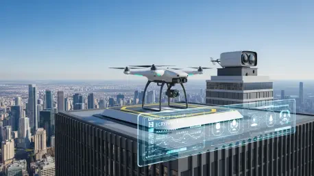
The integration of high-resolution cameras and thermal imaging sensors onto drone platforms allows for a level of situational awareness that was previously impossible without expensive helicopter support. When a call comes in, the Drone as a First Responder (DFR) system automatically launches an aircraft from a localized docking station to provide a bird’s-eye view of the incident as it unfolds. This immediate perspective is critical during high-stakes scenarios such as active shooter reports or structure fires, where every second counts toward a successful outcome. By streaming live video directly to the mobile devices of officers en route, the system ensures that those entering a dangerous situation have a clear understanding of the threats they face. Furthermore, the use of zoom lenses allows for detailed observation from high altitudes, which helps in maintaining a safe distance while still gathering necessary intelligence. This capability not only protects the public but also significantly reduces the physical risks for the responders on the ground.
Building on this foundation, the use of advanced telemetry and artificial intelligence allows these drones to track moving targets or identify heat signatures in dense smoke. Such capabilities are essential for search and rescue operations where time is of the essence, particularly in large parks or wooded areas within city limits. In 2026, the transition from manual piloting to autonomous flight paths has enabled even faster deployments, as the systems can now navigate around obstacles using sophisticated onboard sensors. This evolution means that the visual data collected is more stable and reliable, providing a consistent stream of information that can be recorded for evidence or training purposes. The presence of an aerial asset often de-escalates potentially violent encounters, as individuals are less likely to resist when they realize they are being monitored from above. Consequently, the tactical advantage shifts from reactive to proactive, allowing for a more controlled and surgical response to multifaceted urban emergencies.
Optimization of Emergency Service Resources
Efficiency in resource management is a primary driver for the adoption of DFR programs, as it allows agencies to do more with less in an era of tightening municipal budgets. By sending a drone to investigate a report of a minor disturbance or a suspicious person, dispatchers can often determine that a physical police presence is not required, thereby keeping officers available for higher-priority calls. This triage process minimizes unnecessary vehicle wear and tear and reduces the carbon footprint of the city’s emergency fleet. In many instances, the aerial view reveals that what was reported as a major incident is actually a minor misunderstanding that can be resolved with a single unit rather than a full squad. This level of precision in resource allocation ensures that the most skilled personnel are always where they are needed most. The data gathered during these missions also provides a wealth of information for urban planning and traffic management, further extending the utility of the drone program.
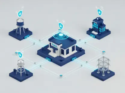
Furthermore, the integration of these programs into existing Computer-Aided Dispatch (CAD) systems has streamlined the communication flow between different departments. When a drone identifies a fire starting in a remote area, it can immediately alert the fire department with exact GPS coordinates, while simultaneously providing police with a visual of the surrounding traffic to assist in clearing a path for fire trucks. This interconnectedness fosters a collaborative environment where information is shared in real-time, reducing the silos that often hinder emergency response. Between 2026 and 2028, cities are expected to expand these networks to include automated charging stations on rooftops, creating a continuous “mesh” of aerial coverage. This infrastructure allows for a sustained presence during long-term events, such as large public protests or festivals, without the need for constant human intervention to swap batteries. The result is a more resilient and responsive public safety network that adapts to the city’s needs.
Establishing Rigorous Data Protection Standards
Tiered Data Management and Privacy Hierarchies
Managing the vast amounts of video and metadata generated by DFR programs requires a sophisticated approach to data governance that prioritizes individual privacy. To achieve this, many organizations have implemented a tiered classification system that separates essential operational data from non-essential personal information. Similar to digital cookie policies, “Strictly Necessary” data includes flight logs and encrypted video evidence required for legal proceedings, which are stored in high-security environments with limited access. “Performance” data, on the other hand, consists of technical metrics used to improve the drone’s flight efficiency and is typically anonymized to prevent the identification of specific individuals or locations. This categorization ensures that sensitive footage is not inadvertently sold or shared with third-party marketing firms, maintaining compliance with modern privacy standards. By clearly defining these boundaries, municipalities can assure residents that their digital footprint is being handled with the utmost care.
This approach naturally leads to the implementation of automated redaction software, which can blur faces and license plates in real-time unless a specific legal threshold is met. This technology allows the public to see that the primary goal is safety, not indiscriminate surveillance of law-abiding citizens. Access to the raw, unredacted footage is usually governed by strict protocols, requiring a documented “need to know” and an audit trail that tracks every time the data is viewed or downloaded. In the current 2026 landscape, cloud-based storage solutions offer end-to-end encryption, ensuring that even if a breach occurs, the data remains unreadable to unauthorized parties. Furthermore, retention policies are strictly enforced, with non-evidentiary footage being automatically deleted after a set period, such as thirty days. These safeguards are essential for building public trust and ensuring that the technological benefits of the program do not come at the expense of the constitutional right to privacy and freedom from unreasonable search.
Regulatory Compliance and Transparent Governance
The legal landscape surrounding drone operations and data privacy is rapidly evolving, with frameworks like the California Consumer Privacy Act (CCPA) setting the standard for user autonomy. Under these regulations, citizens have the right to know what data is being collected about them and, in some cases, the right to opt out of certain types of tracking. While DFR programs are often exempt from standard opt-out requests during active emergencies, transparency remains a cornerstone of successful implementation. Many cities have launched public-facing dashboards that show where drones are flying in real-time and provide summaries of why they were deployed. This level of openness helps to demystify the technology and demonstrates a commitment to accountability. By providing a clear toggle between public safety needs and private data protections, agencies can navigate the complexities of modern law while still leveraging the power of aerial surveillance to protect the community.
Moreover, independent audits are becoming a standard practice for municipal drone programs to ensure they are adhering to their stated privacy policies. These audits examine everything from flight logs to data storage practices, providing an objective assessment of the program’s impact on civil liberties. If discrepancies are found, the program can be paused or modified until full compliance is achieved, preventing the “mission creep” that often plagues new surveillance technologies. This rigorous oversight is complemented by public forums and advisory committees where residents can voice their concerns and influence the development of future policies. In the years spanning 2026 to 2029, the focus will likely shift toward national standards that harmonize these local efforts, creating a consistent legal framework across all jurisdictions. Ultimately, the goal is to create a sustainable model where public safety and privacy are not seen as competing interests, but as two sides of the same coin, both essential for a thriving and secure urban environment.
Future Considerations for Municipal Drone Integration
Municipalities that successfully implemented DFR programs focused on establishing a clear link between technological deployment and tangible community benefits. They prioritized the creation of robust privacy policies that were both transparent and legally sound, ensuring that every flight had a documented purpose. Leaders in these cities invested in automated redaction technologies and secure cloud storage to mitigate the risks associated with large-scale data collection. By maintaining an open dialogue with the public, these agencies were able to foster an environment of trust where residents felt protected rather than watched. Moving forward, the adoption of standardized auditing processes will remain a critical step for any city looking to scale their aerial capabilities. These steps were instrumental in proving that advanced surveillance could coexist with traditional civil liberties.
Looking ahead, the next phase of drone integration involved the expansion of automated infrastructure and the refinement of artificial intelligence for even more precise incident management. Authorities moved toward cross-jurisdictional data sharing agreements that allowed for a seamless response during regional disasters while maintaining strict privacy controls. Organizations began to experiment with smaller, less intrusive drone designs to reduce the “noise and nuisance” factor in residential neighborhoods. The focus shifted from merely collecting data to analyzing it in ways that predicted and prevented accidents before they occurred. These developments required a continuous commitment to ethical oversight and a willingness to adapt policies as new challenges emerged. By staying ahead of the regulatory curve, city officials ensured that their public safety innovations remained a model for responsible governance and technological excellence.