
In the critical moments of an emergency, first responders frequently navigate chaotic and hazardous indoor environments where situational awareness is the key to survival for both victims and the rescuers themselves. Traditional technologies like GPS become unreliable, leaving personnel vulnerable and incident commanders in the dark. To close this dangerous information gap, government-led initiatives are spearheading the development of groundbreaking technologies designed to see through walls, map complex structures, and track every team member, fundamentally transforming the safety and effectiveness of lifesaving missions.
The Indoor Challenge: Overcoming Technological Blind Spots
Limitations of Conventional Tools
The very technologies that have revolutionized outdoor emergency response often prove inadequate the moment operations move inside a building. Drones, for instance, have become an invaluable asset for aerial surveillance, search and rescue over wide areas, and monitoring large-scale events. However, their utility diminishes sharply within the confines of a structure. Navigating narrow corridors, doorways, and stairwells presents significant physical challenges that most outdoor-optimized drones are not designed to handle. Furthermore, the powerful downdraft from their propellers, known as prop-wash, can create unpredictable turbulence in enclosed spaces, leading to instability and potential crashes. This effect is compounded by dust and debris kicked up from the floor, which can obscure sensors and interfere with sensitive electronics, rendering the drone a liability rather than an asset in the very environments where visual intelligence is most needed.
Beyond the physical limitations of flight, the foundational technologies enabling modern navigation and communication fail catastrophically indoors. Global Positioning System (GPS) signals, which are relatively weak by the time they reach the Earth’s surface, are easily blocked by common building materials such as concrete, steel, and even dense roofing. This signal attenuation creates a “digital blackout,” making it nearly impossible to accurately track personnel or guide autonomous devices. An incident commander, who relies on knowing the precise location of every team member, is left with a dangerous information vacuum. This technological blind spot means that a firefighter who becomes disoriented in a smoke-filled room or a police officer isolated during an active event cannot be easily located, severely complicating coordination, resource deployment, and potential rescue efforts for the responders themselves.
Charting the Unseen: The Push for Indoor Mapping
To address the profound challenge of operating within an unknown and hazardous interior, the National Institute of Standards and Technology (NIST) has taken a proactive role by sponsoring prize competitions aimed at advancing 3D indoor mapping. The central objective of these initiatives is to incentivize innovators to create sophisticated drone systems capable of flying autonomously through complex, GPS-denied environments. These drones must not only navigate without external guidance but also simultaneously generate high-fidelity, three-dimensional maps and imagery in real time. The complexity of this task cannot be overstated, as it requires the integration of advanced sensors like LiDAR and cameras, sophisticated simultaneous localization and mapping (SLAM) algorithms, and robust data transmission capabilities to relay the intricate spatial information back to a command center.
The practical value of this technology for first responders is transformative, providing a level of situational awareness that was previously unattainable. Before committing human teams to a potentially unstable or dangerous structure, an incident commander can deploy a mapping drone to conduct a rapid and thorough reconnaissance. The resulting 3D map offers an unprecedented pre-entry visualization of the environment, revealing critical details such as the locations of potential victims, the integrity of structural elements, the presence of impassable debris, and the safest possible routes for entry and egress. As noted by officials involved in the program, this capability fundamentally changes the operational calculus from one of reactive guesswork to one of proactive, intelligence-driven strategy. It is about saving lives—both those of the public and the responders—by replacing uncertainty with actionable, spatial intelligence.
A New Generation of First Responder Tools
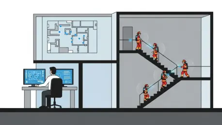
A Digital Lifeline: Pinpointing Responders’ Locations
The second critical vulnerability for first responders inside buildings is the inability to precisely track their location. The failure of GPS indoors means that once a team enters a structure, their position becomes an estimate at best. This creates a high-risk scenario where commanders can lose a clear operational picture, complicating team coordination and making it exceedingly difficult to direct a rescue if a responder becomes trapped, injured, or disoriented. To solve this life-or-death problem, NIST and its partners launched the First Responder Smart Tracking (FRST) Challenge. This initiative was designed to spur the development of affordable, rugged, and wearable devices that can provide continuous, accurate location data from deep within complex, multi-story buildings. The challenge sought a system that could function independently of pre-installed infrastructure, making it viable for any emergency scenario.
The ideal solution emerging from this challenge is a system that can track an individual’s movement not just on a two-dimensional plane but also vertically, accounting for travel through stairwells and between floors. This technology must be robust enough to withstand the harsh conditions of a fire or a structural collapse and simple enough to be seamlessly integrated into a first responder’s standard gear. By relaying this precise location data back to a command center in near real-time, the system acts as a digital lifeline. It provides commanders with a dynamic map showing the position of every team member, enabling them to direct movements, avoid hazards identified by mapping drones, and immediately dispatch assistance to a downed colleague’s exact location. This is not merely a tool for convenience; it is a critical safety net that ensures no one is left unaccounted for in the chaos of an emergency.
Augmenting Human Expertise, Not Replacing It
A guiding principle throughout the development of these advanced technologies is the augmentation of human capability, not its replacement. The innovations in drone mapping and personnel tracking are not intended to create fully autonomous robotic responders that operate independently of human oversight. Instead, they are conceived as powerful tools that enhance the perception, decision-making, and safety of experienced emergency professionals. The drone functions as an advanced scout, venturing into hazardous areas to gather vital intelligence and prepare the way for human teams. The indoor tracking system serves as a digital guardian, providing a constant stream of location data that gives commanders a clear and comprehensive view of their personnel’s deployment and exposure to potential risks.
This human-centric approach ensures that the invaluable experience, intuition, and judgment of first responders remain at the core of the emergency response. Technology provides the data, but humans provide the context and make the critical decisions. For example, a 3D map might show a clear path, but an experienced firefighter might recognize subtle signs of structural instability that the drone’s sensors missed. Similarly, a tracking system shows where a team is, but a commander uses their expertise to decide how to deploy them most effectively based on that information. By empowering responders with better information, these tools amplify their inherent skills, allowing them to perform their duties more safely and efficiently, ultimately leading to better outcomes for everyone involved.
Forging Field-Ready Solutions Through Realistic Testing
The Proving Ground for Lifesaving Tech
To ensure these innovative technologies are truly prepared for the rigors of real-world emergencies, NIST established the Public Safety Immersive Test Center in Colorado. This state-of-the-art facility serves as a crucial proving ground, providing a controlled and repeatable environment for the holistic evaluation of new emergency response systems. Its key advantage is the ability to simulate a wide range of realistic disaster scenarios, from smoke-filled corridors and maze-like interiors to mock-ups of collapsed structures. This allows developers and first responders to test not only how individual devices perform under extreme stress but also how they function together as an integrated system. The transition from a controlled lab to a chaotic emergency scene is fraught with unforeseen challenges, and this center is designed to bridge that critical gap.
This capacity for integrated, high-fidelity testing is a critical step in maturing these tools from promising prototypes to field-ready, lifesaving equipment. For instance, researchers can simultaneously test a drone’s mapping performance in a smoke-obscured environment while tracking personnel equipped with new localization devices as they navigate the same space. This allows for a comprehensive analysis of the entire technological ecosystem, identifying potential issues like radio frequency interference between systems or data integration problems at the command center. By subjecting these tools to the punishing conditions they will face in the field, the center helps guarantee that the technology delivered to first responders is not just functional but also exceptionally reliable and interoperable, ensuring it will work when every second counts.
A New Standard of Operational Readiness
The establishment of a dedicated and realistic testing environment has marked a fundamental shift in how public safety technology was developed and deployed. Previously, innovations often moved from the laboratory to the field with limited validation in complex, multi-system scenarios. The immersive test center provided a platform where the interplay between different technologies—such as a mapping drone providing data to a commander who then directs a tracked team—could be examined and refined. This integrated approach has ensured that the new toolkit being created was more than just a collection of individual gadgets; it was a cohesive system designed to enhance situational awareness from every angle. The insights gained from these rigorous evaluations have led to more resilient hardware, more intuitive software, and a deeper understanding of how to best leverage these tools in the field. This focus on realistic validation has ultimately accelerated the creation of a new generation of equipment that promised to significantly reduce confusion and save lives in the most challenging indoor environments.