
When firefighters and rescue teams breach the entrance of a structurally compromised building, the advanced navigation and communication tools they rely on outdoors abruptly cease to function, plunging them into a dangerous information vacuum. This critical “indoor blind spot” is a long-standing challenge where GPS signals are blocked by concrete and steel, rendering digital maps useless and leaving incident commanders without a clear picture of the environment their teams are entering or their precise locations within it. This technological gap creates two life-threatening problems: a profound lack of situational awareness regarding interior layouts and hazards, and the inability to accurately track personnel who may become disoriented, injured, or trapped. Responders are forced to rely on training, instinct, and limited radio contact, making high-stakes decisions with incomplete data in chaotic settings where every second is critical to the survival of both civilians and the responders themselves. Addressing this vulnerability has become a paramount objective for public safety innovation.
Eyes in the Sky for Confined Spaces
To penetrate this indoor fog of war, government-backed initiatives are accelerating the development of specialized drones designed to operate where conventional unmanned aerial vehicles cannot. These are not standard consumer drones; they are sophisticated autonomous systems engineered to navigate the treacherous, GPS-denied interiors of collapsed buildings, smoke-filled warehouses, and other hazardous structures. Through focused prize challenges, agencies like the National Institute of Standards and Technology (NIST) have incentivized the creation of drones that can manage complex flight paths through narrow corridors and around unseen obstacles, all while generating high-fidelity 3D maps in real time. These machines serve as robotic scouts, flying ahead of human teams to gather vital intelligence without putting personnel at risk. Their mission is to autonomously explore and map the unknown, transforming a chaotic and dangerous environment into a structured, understandable digital model that can inform every subsequent action of the rescue operation.
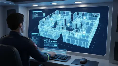
The practical impact of this technology is a paradigm shift in how emergency operations are managed, moving from reactive navigation to proactive, data-driven strategy. The real-time maps and imagery streamed from these indoor drones provide incident commanders with an unprecedented level of situational awareness. Before deploying a team, a commander can virtually tour the interior of the structure, identifying the most stable routes, pinpointing the exact locations of victims, and recognizing potential hazards such as structural weaknesses or spreading fires. This “usable intelligence,” as described by NIST officials, removes the guesswork that has historically defined indoor rescue missions. Instead of sending responders in blind, commanders can equip them with a clear and detailed plan, maximizing the efficiency of the search and rescue effort while dramatically mitigating the risks to their own personnel. This foresight saves invaluable time and, ultimately, saves lives on both sides of the rescue line.
A Digital Lifeline for Every Responder
Complementing the effort to map hazardous interiors is a parallel technological push to solve the persistent problem of personnel invisibility once teams are inside. In a sprawling, multi-story structure, an incident commander losing the precise location of a team is a dire scenario that can paralyze an operation and delay aid to a downed responder. To address this, innovation is focused on creating a reliable “indoor GPS” system. Through initiatives like the First Responder Smart Tracking (FRST) Challenge, NIST is fostering the development of rugged, affordable, and easily wearable localization devices. These systems are designed to function flawlessly in environments where satellite signals cannot penetrate, continuously transmitting the exact position of each team member back to a central command hub. The goal is to equip every responder with a personal tracking unit that is as fundamental to their gear as their radio or self-contained breathing apparatus, ensuring no one is ever truly lost.
This real-time tracking capability provides commanders with a comprehensive, “God’s-eye view” of all personnel operating within a structure, displayed on a dynamic digital map. Such a system revolutionizes team coordination, allowing for more strategic and synchronized movements, especially in complex scenarios involving multiple units. It eliminates the confusion that can arise from vague radio communications about location and allows for the immediate and precise deployment of a rapid intervention team to a responder who is in distress. If a firefighter becomes incapacitated or a paramedic is cut off from their team, their location is known instantly, allowing help to be dispatched to their exact position without a time-consuming search. This constant stream of location data creates an invisible lifeline, providing a powerful new layer of safety and operational control that enhances the security and effectiveness of the entire response team during their most vulnerable moments.
Validating Innovations on the Front Line
The successful transition of these advanced technologies from promising prototypes to reliable, field-ready tools depended heavily on rigorous testing in environments that mirrored real-world emergencies. This crucial validation phase was addressed through the establishment of specialized facilities like NIST’s Public Safety Immersive Test Center. This state-of-the-art center provided a controlled yet realistic proving ground where developers and first responders could collaborate to stress-test emerging systems. Here, drone mapping algorithms, indoor tracking devices, and next-generation communication gear were subjected to repeatable disaster simulations, allowing for a thorough evaluation of their performance under pressure. This bridge between the laboratory and the front line was essential for refining the technology and ensuring its practical utility and durability in the chaotic conditions of an actual emergency.
Ultimately, these integrated testing efforts ensured that the individual components worked together as a cohesive system. The process confirmed that the data from mapping drones could be seamlessly integrated with personnel tracking systems, providing a unified operational picture for incident commanders. This collaborative evaluation helped identify and resolve interoperability issues before the equipment was ever deployed in a life-or-death situation. The overarching philosophy driving these developments was not the replacement of human skill and judgment but their augmentation with superior information. The outcome of these government-spurred advancements was a new generation of tools poised to become as fundamental to a first responder’s toolkit as their protective gear, giving them the critical data needed to make smarter, safer decisions and successfully complete their missions.