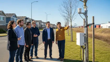

The cityscape of Chicago is currently undergoing a silent transformation as 277 solar-powered air quality monitors begin to map the invisible boundaries of environmental inequality across all fifty city wards. This initiative, known as Open Air Chicago, represents the most extensive community-based air monitoring network in the United States, designed specifically to move beyond general citywide averages. By providing granular and real-time data, the project seeks to highlight the specific risks faced by residents who live near industrial corridors compared to those in more affluent neighborhoods. The origins of this massive undertaking can be traced back to a federal civil rights complaint regarding the relocation of a large scrap-metal operation from the city’s North Side to the Southeast Side. This legal battle culminated in a settlement that prioritized environmental justice, turning years of grassroots advocacy into a well-funded scientific partnership between the city and the University of Illinois Chicago.
Refining the Technical Edge: Precision in Localized Monitoring
The technological backbone of this network relies on high-precision sensors that specifically target nitrogen dioxide and fine particulate matter, commonly known as PM2.5. These microscopic particles are particularly dangerous because they are small enough to enter the human bloodstream, where they can cause severe respiratory issues and long-term cardiovascular damage. By collecting more than 20,000 data points every day, the system is capable of identifying localized “hot spots” that were previously ignored by broader regional monitors. This high-frequency data collection allows municipal researchers to track how pollution levels fluctuate hour by hour in direct response to traffic congestion and heavy industrial activity. Unlike older systems that provided delayed or aggregated results, this real-time approach offers a vivid picture of the atmosphere at a street-level resolution. Understanding these fluctuations is critical for pinpointing the exact moments when air quality becomes hazardous for the public.
Bridging the Gap: Comparing Local and Regional Data
While traditional federal equipment maintained by the Environmental Protection Agency provides the official gold standard for precise measurements, these massive units are often too expensive and sparse to capture neighborhood-level variations. Chicago’s dense network of lower-cost sensors effectively bridges this gap, providing a comprehensive view of the air quality that residents actually breathe during their daily lives. This localized strategy is essential for identifying the specific sources of pollution that contribute to disproportionate rates of childhood asthma and other chronic health conditions in neglected zip codes. By saturating the city with these agile devices, the program can detect plumes of exhaust or industrial smoke that might dissipate before reaching a distant regional station. This level of detail transforms the air from an abstract concept into a measurable public health factor. It ensures that the unique environmental burdens of each community are no longer hidden behind citywide averages.
Managing Seasonal Crises: Heatwaves and Ozone Crucibles
During the sweltering summer months, the city often faces a crucible of air quality challenges as intense heat and sunlight catalyze chemical reactions between industrial emissions and vehicle exhaust. This process creates ground-level ozone, a dangerous component of smog that can trigger immediate respiratory distress for vulnerable populations, especially those living near freight hubs and heavy manufacturing zones. The Open Air Chicago network allows researchers to observe how these concentrations shift across the complex geography of the city, revealing the uneven nature of atmospheric hazards during record-breaking heatwaves. By mapping these trends, the city can better understand how urban heat islands exacerbate the toxicity of the air in specific neighborhoods. This data is vital for emergency services and public health officials who must decide where to deploy resources during peak pollution events. It also provides a baseline for understanding how localized cooling initiatives might eventually mitigate these recurring threats.
Global Atmospheric Shifts: Wildfires and Satellite Validation
External factors such as North American wildfires also play a critical role in the local atmosphere, as massive smoke plumes from thousands of miles away can infiltrate the city’s airspace. These fires are effectively reversing decades of progress made under federal air regulations, making local monitoring essential for tracking how these unpredictable events impact urban health. The data from the new network helps scientists determine whether the smoke observed by satellites high in the atmosphere is actually descending into the “breathing zone” where it can harm residents. By combining this ground-level evidence with NASA satellite surveillance, researchers can more accurately distinguish between high-altitude haze and the dangerous particulates reaching people on the street. This synergy allows for the creation of more sophisticated atmospheric models that account for both local industrial output and regional environmental disasters. This verification ensures that public warnings are based on the most accurate information.
Bridging Information Gaps: Advocacy and Medical Science
The integration of granular air data with medical records allows health experts to link specific pollution spikes to emergency room visits and respiratory flare-ups with unprecedented accuracy. By tracking the exact time and location of a particulate surge, researchers can correlate these events with instances of hospitalizations for asthma or heart failure in the immediate vicinity. This scientific rigor provides a powerful tool for public health advocates who have long argued that industrial placement has a direct impact on the longevity and wellbeing of city residents. Furthermore, this information enables healthcare providers to issue proactive warnings to patients when local conditions are predicted to deteriorate. Instead of general advice, doctors can offer neighborhood-specific guidance, helping high-risk individuals manage their conditions more effectively. The resulting database serves as a permanent record of the intersection between environmental conditions and public health outcomes.
Empowering Communities: Combatting Environmental Gaslighting
For residents living on the South and West Sides, the network serves as a vital tool to combat what has been described as “environmental gaslighting” by providing hard evidence of the pollution they have long reported. For years, many communities felt that their concerns regarding air quality were dismissed or ignored due to a lack of official data. Real-time access to air quality indexes via smartphones now allows families to make informed decisions about their daily lives, such as determining whether it is truly safe for children to play outside on a given afternoon. This level of transparency fosters a sense of agency in communities that have historically been sidelined or excluded from environmental discussions. When residents can see the data for themselves, they are better equipped to hold both the city and local industries accountable for their environmental footprints. This democratic access to information levels the playing field for every citizen within their own neighborhood.
Transforming Statistics: Sustainable Urban Policy and Planning
Moving forward, municipal leaders intend to use this wealth of information to reshape fundamental policies, including industrial permitting processes and freight management strategies. If specific industrial corridors show consistent levels of toxic pollutants over several months, officials may use that data to justify rerouting heavy trucking or incentivizing the rapid electrification of commercial vehicles in those specific areas. This approach ensures that future urban development is guided by public health needs rather than merely following the path of least economic resistance. By integrating air quality metrics into the zoning process, the city can prevent the further clustering of high-pollution facilities in already overburdened neighborhoods. This data-driven policy shift represents a move toward a more proactive form of urban governance, where environmental health is considered a prerequisite for new commercial projects. It also provides a clear framework for measuring the success of green initiatives.
Long-Term Commitments: Building a Resilient Urban Ecosystem
The Open Air Chicago program is currently scheduled to operate through 2029, with the potential for expansion into tracking a wider range of air toxins and volatile organic compounds. This long-term commitment aims to build a sustainable foundation for environmental equity, ensuring that every resident has access to clean air regardless of their neighborhood or socioeconomic status. By establishing an ongoing, historical record of air quality, the city is setting a significant precedent for how modern urban centers can leverage technology to protect their most vulnerable populations. This project serves as a model for other metropolitan areas looking to bridge the gap between high-level environmental goals and the lived reality of their citizens. As the sensor technology continues to evolve, the network will likely become even more integrated into the daily operations of city departments, from transportation to education. The ultimate goal is to create a city where air quality is no longer a predictor of health.
Implementing Solutions: The Path Toward Environmental Equity
The establishment of the air monitoring network represented a decisive step toward rectifying decades of environmental neglect in underserved communities. By deploying hundreds of sensors, the city successfully moved away from anecdotal evidence and toward a framework of scientific accountability. It was clear from the outset that data alone would not clean the air, but rather provide the necessary evidence to drive legislative and structural changes. Officials utilized the findings to initiate the first phases of a comprehensive truck rerouting plan that targeted the most polluted residential zones. This transition required close collaboration between urban planners, public health experts, and community leaders to ensure that the solutions addressed the root causes of atmospheric degradation. The project demonstrated that transparency was the most effective tool for building trust between the government and the public. Future focus shifted to expanding the sensor grid into public schools.